Plot GPS Waypoints in AutoCAD and View them on Terraserver-USA Maps!
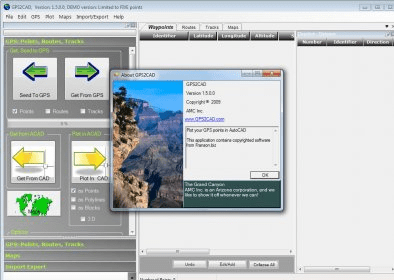
GPS2CAD enables design professionals to use recreational-grade GPS units to collect field information and plot it in their CAD program. While professional survey-grade systems are more accurate, most recreational GPS units are well-suited for many site layout and "topo-plotting" requirements.
Viewing the imported points on actual public-domain aerial photos or topographic maps is an important part of GPS2CAD. These maps are obtained automatically when the user clicks the "View Points" button, and then displayed in a separate window with the map, points and id clearly plotted.
GPS2CAD translates the GPS points from their "satellite based" coordinate system into more than 40 world wide coordinate systems, including the extremely popular NAD 27, NAD 83, and the State Plane Coordinate systems (used in the United States).
The program is designed to work with AutoCAD, versions 14.01 through 2005. In addition, it will export the point data to text files, Access 2000 files, and DXF files, so most technical/CAD programs (including AutoCAD LT) can use the point data.

Engineering tool used to manage single Mediatrix units or small amount of units.

A simple free tool to convert between nearly all known units of density.


Comments